


NASA sees major winter storm headed for eastern U.S.
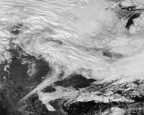
"The Visible Infrared Imaging Radiometer Suite (VIIRS) instrument aboard Suomi NPP satellite captured the visible image on January 20, 2016 at 19:30 UTC (2:30 p.m. EST) when the storm was over the central U.S. In the image, snow cover is visible in the Rockies and southern Great Lakes states," read the NASA website.
VIIRS collects visible and infrared imagery and global observations of land, atmosphere, cryosphere and oceans.
That low pressure system located over the south central United States on Jan. 21 is expected to track east across the Tennessee Valley and will give way to a deepening coastal low pressure area. The National Weather Service said "This latter feature takes over and becomes a dominant force in setting up heavy snow bands over the Mid-Atlantic and very gusty winds."
The storm system is expected to bring an increased risk of severe weather from far southeastern Texas across southern Louisiana/Mississippi, and into the far western Florida Panhandle on Thursday, Jan. 21. That threat for severe weather will move east as the low pressure area continues heading in that direction.
The National Weather Service Weather Prediction Center in College Park, Maryland said "A potentially crippling winter storm is anticipated for portions of the mid-Atlantic Friday into early Saturday. Snowfall may approach two feet for some locations, including the Baltimore and Washington, D.C. metro areas. Farther north, there is uncertainty in snowfall for the New York City-to-Boston corridor. Farther south, significant icing is likely for portions of Kentucky and North Carolina."
A 21 second animation of infrared and visible imagery from NOAA's GOES-East satellite from Jan. 19 to 21 shows the movement one frontal system moving across the southern U.S. followed by a second storm system that is expected to bring the powerful winter storm to the Mid-Atlantic. The animation was created by NASA/NOAA's GOES Project at NASA's Goddard Space Flight Center in Greenbelt, Maryland. GOES satellites are managed by NOAA, and the NASA/NOAA GOES Project creates imagery and animations using the GOES satellite data.
Early on Jan. 21, the NWS hazards web page showed a winter storm watch stretching from the Tennessee valley into the interior Carolinas and up into the Central Appalachians/Mid-Atlantic region. Even a blizzard watch is in effect across the Washington, D.C. metro area along with adjacent locations.
Image: NASA Goddard Rapid Response
Support Our Journalism
We cannot do without you.. your contribution supports unbiased journalism
IBNS is not driven by any ism- not wokeism, not racism, not skewed secularism, not hyper right-wing or left liberal ideals, nor by any hardline religious beliefs or hyper nationalism. We want to serve you good old objective news, as they are. We do not judge or preach. We let people decide for themselves. We only try to present factual and well-sourced news.
Support objective journalism for a small contribution.


