 EOS-06
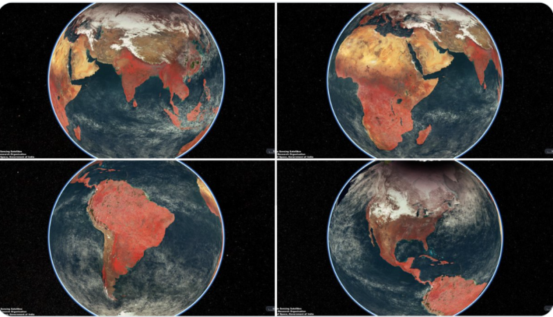
 Earth images captured by EOS-06 satellite released by ISRO
Chennai: The Indian Space Research Organisation (ISRO) has released the images of earth captured by EOS-06 Satellite launched by its reliable launch vehicle PSLV on November 26, 2022.
In a series of tweets, ISRO said NRSC/ISRO has generated global False Colour Composite (FCC) mosaic from the images captured by theOcean Colour Monitor (OCM) payload on board EOS-06.
The mosaic with 1 km spatial resolution is generated by combining 2,939 individual images, after processing 300 GB data to show the Earth as seen
during February 1-15, 2023, it said.
(2/2) OCM senses the Earth in 13 distinct wavelengths to provide information about global vegetation cover on Land and Ocean Biota for global oceans. pic.twitter.com/IbJ7kSw69X
— ISRO (@isro) March 29, 2023
OCM senses the Earth in 13 distinct wavelengths to provide information about global vegetation cover on Land and Ocean Biota for global oceans.
ISRO’s workhorse PSLV-C54 had successfully launched EOS-06 satellite along with eight Nano-satellites into two different SSPOs from the Satish
Dhawan Space Centre SHAR Range, Sriharikota on November 26, 2022.
EOS-06 is third generation satellite in the Oceansat series, which provides continued services of Oceansat-2 with enhanced payload capability.
The satellite onboard carried four important payloads viz. Ocean Color Monitor (OCM-3), Sea Surface Temperature Monitor (SSTM), Ku-Band Scatterometer (SCAT-3), ARGOS.
The Oceansat-2 which was launched during September-2009 configured to cover global oceans and provide continuity of ocean colour data with global wind vector and characterization of lower atmosphere and ionosphere.
The mission resulted in many research collaborations nationally and internationally on various areas global chlorophyll distribution, Kd 490 distribution, ocean color images, oil spillages, wind vector products.
(With UNI inputs)
Support Our Journalism
We cannot do without you.. your contribution supports unbiased journalism
IBNS is not driven by any ism- not wokeism, not racism, not skewed secularism, not hyper right-wing or left liberal ideals, nor by any hardline religious beliefs or hyper nationalism. We want to serve you good old objective news, as they are. We do not judge or preach. We let people decide for themselves. We only try to present factual and well-sourced news.


