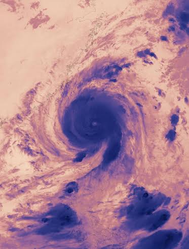
NASA looks at Typhoon Nepartak over Taiwan in visible and infrared Ligh
The MODIS instrument aboard NASA's Aqua satellite read cloud top temperatures in a thermal image of Typhoon Nepartak on July 7 at 17:45 UTC (1:45 p.m. EDT) as it was approaching Taiwan. The infrared temperature data enables scientists to learn where the strongest storms are located within a typhoon. The colder the cloud tops, the higher they are in the troposphere and the stronger the storms. NASA data has shown that cloud tops that are as cold as minus 63 degrees Fahrenheit (minus 53 degrees Celsius) have the ability to generate heavy rainfall. Rainfall totals compiled by Taiwan's Central Weather Bureau confirmed high rainfall totals, read the NASA website.
On July 8 at 03:10 UTC (July 7 at 11:10 p.m. EDT) the MODIS instrument aboard NASA's Terra satellite captured a visible image of Typhoon Nepartak that showed the storm over Taiwan.
Taiwan Central Emergency Operations Center reported three deaths and 142 injuries.
At 12 p.m. EDT (1600 UTC) on July 8, 2016, Taiwan's Central Weather Bureau noted several advisories in effect. Torrential Rain Advisory areas include: Nantou County Mountain Area, Chiayi County Mountain Area, Tainan City Mountain Area, Kaohsiung City, Pingtung County, Hengchun Peninsula, Hualien County Mountain Area and Taitung County Mountain Area.
An Extremely Heavy Rain Advisory remains in effect for the Taichung City Mountain Area, Yunlin County Mountain Area, Chiayi City, Chiayi County, Tainan City, Yilan County Mountain Area, Hualien County, Taitung County, Lanyu and Ludao Islands and Penghu County.
A Heavy Rain Advisory is in effect for the Taipei City Mountain Area, New Taipei City Mountain Area, Taoyuan City Mountain Area, Hsinchu County Mountain Area, Miaoli County Mountain Area, Taichung City, Changhua County, Nantou County, Yunlin County, Yilan County, Kinmen Area and Matsu Area.
At 1500 UTC (11 a.m. EDT) on July 8, 2016 Typhoon Nepartak had maximum sustained winds near 70 knots (80.5 mph/129.6 kph). The center of the storm was located near 23.3 north latitude and 119.7 east longitude, about 146 nautical mile southwest of Taipei, Taiwan. Nepartak was moving slowly across the Taiwan Strait at 4 knots (4.6 mph/7.4 kph) in a northwesterly direction.
The Joint Typhoon Warning Center (JTWC) noted that the central circulation has been decoupled so the system is no longer stacked on top of itself. The strongest thunderstorms and flaring convection is occurring along the southern quadrant of the storm. JTWC said "Typhoon Nepartak is forecast to continue weakening in the near term due to the decoupled nature of the system, and its close proximity to land."
Credits: NASA Goddard MODIS Rapid Response
Support Our Journalism
We cannot do without you.. your contribution supports unbiased journalism
IBNS is not driven by any ism- not wokeism, not racism, not skewed secularism, not hyper right-wing or left liberal ideals, nor by any hardline religious beliefs or hyper nationalism. We want to serve you good old objective news, as they are. We do not judge or preach. We let people decide for themselves. We only try to present factual and well-sourced news.


