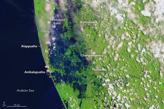
NASA unveils 'before and after' images of flood-hit Kerala
Washington, Aug 28 (IBNS): NASA has unveiled images where it has shown the destruction caused by floods in the Indian city of Kerala.
The US space agency has highlighted the 'before and after' condition of the state since the flood hit it.
The images highlight the extent to which the flood affected the landscape of the state.
"The Operational Land Imager (OLI) on the Landsat 8 satellite acquired the left image (bands 6-5-3) on February 6, 2018, before the flood. The Multispectral Instrument on the European Space Agency’s Sentinel-2 satellite acquired the right image (bands 11-8-3) on August 22, 2018, after flood water had inundated the area. The images are false-color, which makes flood water appear dark blue. Vegetation is bright green," read the NASA Earth Observatory website.
"Several rivers throughout the region spilled over their banks. Water from the Karuvannur River ran through 40 villages, and washed away a 2.2 kilometer (1.4 mile) stretch of land connecting two national highways. Elevated water levels along the Periyar River displaced thousands of people," it said.
Kerala has been hit by flood in recent times and claimed over 400 lives so far.
Support Our Journalism
We cannot do without you.. your contribution supports unbiased journalism
IBNS is not driven by any ism- not wokeism, not racism, not skewed secularism, not hyper right-wing or left liberal ideals, nor by any hardline religious beliefs or hyper nationalism. We want to serve you good old objective news, as they are. We do not judge or preach. We let people decide for themselves. We only try to present factual and well-sourced news.


