 Mocha
Mocha
Severe Cyclonic storm Mocha intensifies into Very Severe Cyclonic Storm: IMD
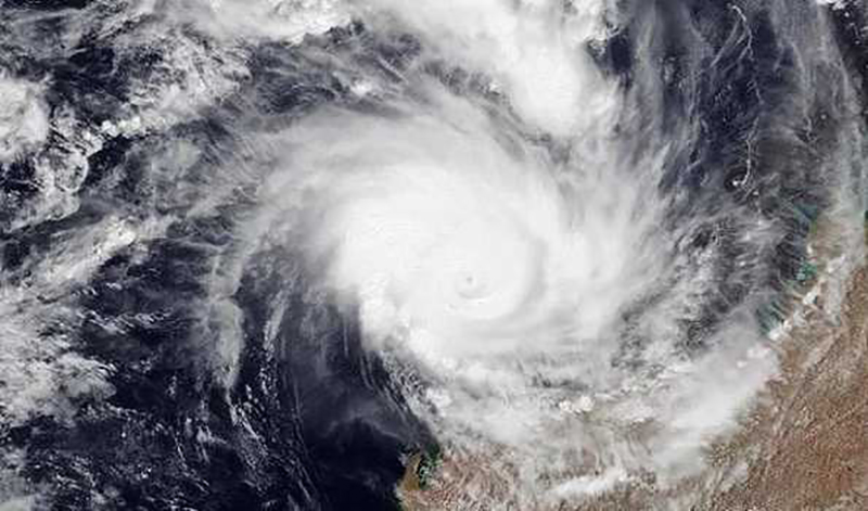
Bhubaneswar/UNI: Severe Cyclonic storm “Mocha” (pronounced as “Mokha”) over Southeast adjoining Central Bay of Bengal has intensified into a Very Severe Cyclonic Storm over
Central adjoining Southeast Bay of Bengal, IMD sources said.
It said the Severe Cyclonic Storm “Mocha” moved northwards with a speed of 09 kmph during the past six hours, intensified into a Very Severe Cyclonic Storm and lay centred on Friday over the Central adjoining Southeast Bay of Bengal.
It lay centred about 520 km west-northwest of Port Blair, 1010 km south-southwest of Cox’s Bazar (Bangladesh) and 930 km south-southwest of Sittwe (Myanmar).
It is very likely to move north-northeast wards and intensify further over East Central Bay of Bengal and across southeast Bangladesh and north Myanmar coasts between Cox’s Bazar (Bangladesh) and Kyaukpyu (Myanmar), close to Sittwe (Myanmar) around noon of May 14 as a Very Severe Cyclonic Storm with a maximum sustained wind speed of 150-160 kmph gusting to 175 kmph.
The System is under continuous surveillance, the IMD said adding that under the influence of the systemSqually wind speed reaching 50-60 kmph gusting to 70 kmph is likely to prevail over North Andaman Sea on May 12.
Gale wind speed reaching 115-125 kmph gusting to 135 kmph is prevailing and likely to continue over Southeast Bay of Bengal till evening and decrease thereafter becoming squally wind speed reaching 55-65 kmph gusting to 75 kmph on May 13.
Squally wind speed reaching 50-60 kmph gusting to 70 kmph is likely to prevail during next 24 hours in the adjoining areas of southwest Bay of Bengal and decrease thereafter.
The Gale wind speed reaching 115-125 kmph gusting to 135 kmph is prevailing over the Eastcentral Bay of Bengal region and it is likely to increase becoming Gale wind speed reaching 140-150 kmph gusting to 165 kmph from May 12 evening and increase further becoming 150-160 kmph gusting to 175 kmph till May 14 morning and gradually decrease thereafter.
The Gale wind speed reaching 115-125 kmph gusting to 135 kmph is likely to prevail over the southeastern sector of the West-central Bay of Bengal region during the next 24 hours and will decrease gradually becoming 90-100 kmph gusting to 110 kmph by May13 evening and significantly decrease thereafter.
Squally wind speed reaching 55-65 kmph gusting to 75 kmph is likely from the forenoon of May 12 in the Northeast Bay of Bengal. Gale wind speed reaching 90-100 kmph gusting to 110 kmph is likely to commence from May 13 morning and gradually increase and become 150-160 kmph gusting 175 kmph from May 13 evening till May 14 noon. It is likely to decrease rapidly after the land fall.
The sea condition will be very rough to rough over north Andaman Sea during May 12- May 13 and High to very high sea condition is likely to prevail during next 24 hours in the Southeast Bay of Bengal.
Very High sea condition is prevailing in the East central Bay of Bengal and is likely to become phenomenal from the morning hours on Friday till May 14forenoon. It will improve thereafter.
Very high sea conditions are prevailing in the adjoining areas of the Westcentral Bay of Bengal and are likely to become phenomenal from May 12 to May 13 morning. It will gradually improve thereafter.
The Northeast Bay of Bengal will witness rough to very rough from May 12 morning and likely to become very rough to high from may 12 evening and high to very high from early morning hours of May 13. It will be Phenomenal during May 13 evening to May 14.
The Fishermen, ships, boats and trawlers are advised not to venture into southeast Bay of Bengal and adjoining Andaman Sea till May 13, central Bay of Bengal and north Andaman Sea till May 14 and into the northeast and adjoining northwest Bay of Bengal during May 12 to May 14.
The Distant Warning Signal No-2 (DW-2) has been hoisted at all ports of Odisha and an advisory issued to regulate tourism and offshore activities and shipping near Andaman & Nicobar Islands till May 13.
Support Our Journalism
We cannot do without you.. your contribution supports unbiased journalism
IBNS is not driven by any ism- not wokeism, not racism, not skewed secularism, not hyper right-wing or left liberal ideals, nor by any hardline religious beliefs or hyper nationalism. We want to serve you good old objective news, as they are. We do not judge or preach. We let people decide for themselves. We only try to present factual and well-sourced news.


