


NASA's GPM Satellite sees potential Atlantic Tropical Cyclone
Shower activity has increased in the area. NOAA's National Hurricane Center (NHC) has advised interests along the southeastern coast of United States to monitor the progress of this low.
If System 91L develops into a tropical cyclone it would be the second in the North Atlantic this year. The first was Hurricane Alex that developed in January in the far eastern Atlantic.
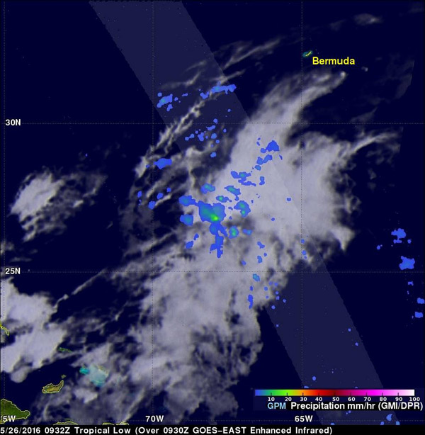
GPM's Microwave Imager (GMI) and Dual-Frequency Precipitation Radar (DPR) instruments measured precipitation around the low. Rain was measured by GPM's radar (DPR) falling at a rate of almost 32 mm (1.3 inches) per hour in an area near the center of the low's circulation. Increasing shower activity near the center of a tropical low can signal tropical cyclone development. Tropical cyclones derive energy from the heat generated by condensation that occurs within showers and thundershowers, read the NASA website.
Data from GPM's DPR was used to the show the 3-D vertical structure of rainfall within the potential cyclone. Some storm top heights in an area of heaviest rainfall were found to reach heights of over 13 km (8 mile). GPM is a joint missions between NASA and the Japanese space agency JAXA.
At 8:25 a.m. EDT on May 26, the National Hurricane Center (NHC) said that System 91L is centered between Bermuda and the Bahamas. NHC noted that the low is gradually becoming better defined while shower activity is increasing. Environmental conditions are expected to become more conducive for tropical or subtropical cyclone formation on Friday while the system moves west-northwestward or northwestward toward the southeastern United States coast.
NHC noted: "With the Memorial Day weekend approaching, all interests along the southeast coast from Georgia through North Carolina should monitor the progress of this low." The system has a medium chance to develop in the next two days and a high chance to develop in to a subtropical or tropical cyclone over the next five days.
Image Credits: NASA/JAXA/SSAI, Hal Pierce
Support Our Journalism
We cannot do without you.. your contribution supports unbiased journalism
IBNS is not driven by any ism- not wokeism, not racism, not skewed secularism, not hyper right-wing or left liberal ideals, nor by any hardline religious beliefs or hyper nationalism. We want to serve you good old objective news, as they are. We do not judge or preach. We let people decide for themselves. We only try to present factual and well-sourced news.
Support objective journalism for a small contribution.


